I have outlined one half of my Northern States Tour.
Stats:
Total distance: 5,005 miles
Travel time: 3 weeks
Number of US States: 11
Number of Canadian Provinces: 7
I have broken out preliminary daily segments below. The segments are written as if I’m traveling easterly on this leg but that may change. The links open google maps to show the day’s tentative route in more detail.
The purpose of this stage of planning is two-fold; to get a relatively accurate calculation of how long the total trip will take; and, to start selecting roads that I want to ride and places I want to ride through.
By determining approximate distances , I can also easily schedule service at BMW dealers ahead of time to avoid delays on the road. Some dealers require booking weeks in advance during the summer riding season.
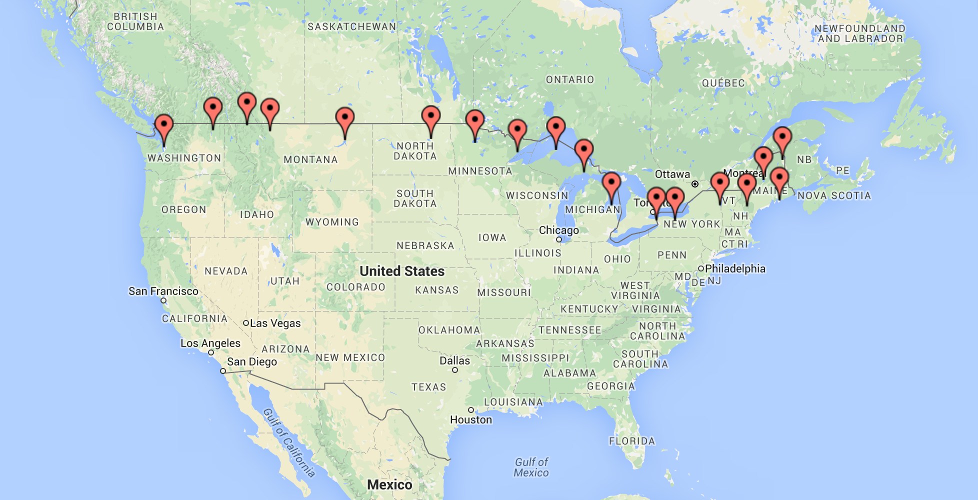
Tentative route:
Week 1
- Seattle to Kettle Falls – (368 miles) Highlights include the North Cascades National Park
- Kettle Falls to Eureka – (327 miles) Highlights include the town of Yaak and Kootenai National Forest, and then along both the western and eastern shores of Lake Koocanusa
- Eureka to Browning – (226 miles) Traveling into British Columbia and Alberta, I’ll add these two provinces to the tour simply for bragging rights at the end of the trip 🙂 Leaving extra time for the multiple border crossings means a lower mileage day planned.
- Browning to Fort Peck – (338 miles) Across the plains of northern Montana north of the Bear Paw Mountains.
- Fort Peck to St John – (412 miles) Hitting North Dakota, one of the new states, I will also cross the border into Saskatchewan and Manitoba before dropping back down into North Dakota. This will be a long day with two border crossings.
- St John to Red Lake – (309 miles) I arrive in Minnesota and just picked Red Lake as a place to stop for the night.
- Red Lake to Silver Bay – (273 miles) Traveling north a bit to ride through the Kabetogama State Forest and the Superior National Forest until arriving at the western shore of Lake Superior.
Week 2
- Silver Bay to Copper Harbor – (373 miles) Travel along the shore of Lake Superior
- Copper Harbor to Naubinway – (300 miles) Travel to Lake Michigan’s northern shore
- Naubinway to Port Austin – (344 miles) Travel along the western shore of Lake Huron
- Port Austin to Niagara Falls – (276 miles) Travel from Michigan to New York via the province of Ontario and along the southwestern shore of Lake Ontario.
- Niagara Falls to Fairport – (112 miles) I’m expecting to need a service and there is a dealer in Fairport, NY.
- Day Off – Scheduled motorcycle service
- Day Off – Scheduled maintenance if overnight needed
Week 3
- Fairport to Port Henry – (321 miles) Starting with Cedarville Road, Llion Gorge (Hwy 51), through the Adirondack Mountains and finishing with Ensign Pond Road into Port Henry, situated on the western shore of Lake Champlain.
- Port Henry to Conway – (182 miles) Traveling through the Green Mountains of Vermont and the White Mountains of New Hampshire.
- Conway to Rockwood – (282 miles) State Highway 17 and 27 have sections that are considered the best for motorcycles. If this route is followed, we enter the province of Quebec briefly so that travel back down through dense forests of Maine.
- Rockwood to Caribou – (292 miles) Reaching north into New Brunswick, we turn south again and finish the day in Caribou, Maine.
- Caribou to Acadia National Park – (270 miles) It would be amazing to be able to stay in the park. We’ll have to see how far ahead I would have to plan this to make reservations. I consider this the end point of this leg of the trip. If that happens, I would stay at least two nights.
- Day Off – Acadia National Park
- Day Off – Acadia National Park
