
On July 10, I depart on a three-day solo motorcycle adventure from Seattle to Baker City, then west through favorite roads in Eastern Oregon before returning past Mount St Helens and Mt Rainier.
Day 1

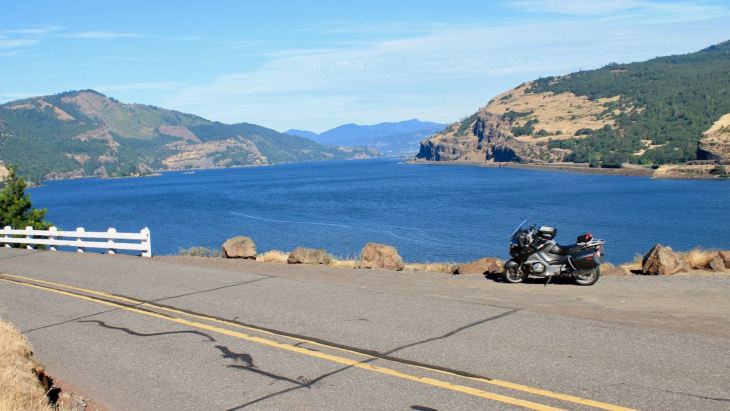
I departed Seattle this morning on a motorcycle adventure to Baker City as part of a three-day solo ride through eastern Oregon and the Gifford Pinchot National Forest.
Today’s distance: 370 miles
Travel time: 8.5+ hours with stops
Temperatures ranged from mid-50 to low-90, depending on the geography and elevation. It was raining, or more like drizzling, in Seattle when I left just after 6:30am.
By the time I stopped in Cle Elum, maybe 90 minutes later, for a latte, the drizzle stopped.

The rest of the day was cloudy but warm and a bit humid.
As is my habit, I like to cut through Yakima Canyon (Hwy 821), which roughly parallels I-82 south from Ellensburg.

Although the posted speed is only 45mph, the road is snake-like and the scenery is better. Even at low speeds, this is far more enjoyable than the interstate.
Soon though, I was in Yakima and back on the interstate.
With the rain and haze, it was just not a good day for vista photos. 😦
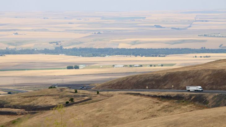
I shortened my route today. I had a more ambitious plan but as the day worn on and the temperature rose above 90, I just wanted to beeline it to the pool! LOL
As I entered the Blue Mountains just after taking the above photo, the temperatures dropped dramatically, down to 73 at the lowest I noticed. It was 84 in Baker City at its peak. You gotta love it.
I don’t think the photos really shows how green the hills still are for this time of year. And there were so many interesting smells today from the grasses, fields, and fruit orchards.
When you’re on a bike, even wrapped up in gear, your exposure to the immediate environment is intense. I can sense the sprinklers in the field by the relative chill in the air at one point today. It’s so cool.
Today’s goal was to get to Baker City. Tomorrow, I’ll be heading west from Baker City along some of my favorite eastern Oregon roads from past rides, specifically my 2017 Eastern Oregon Loop and my 2015 Trip to Fossil.
Evening update
I did meet two bikers and their pillions (passengers) who’ve arrived for the Hells Canyon Motorcycle Rally.
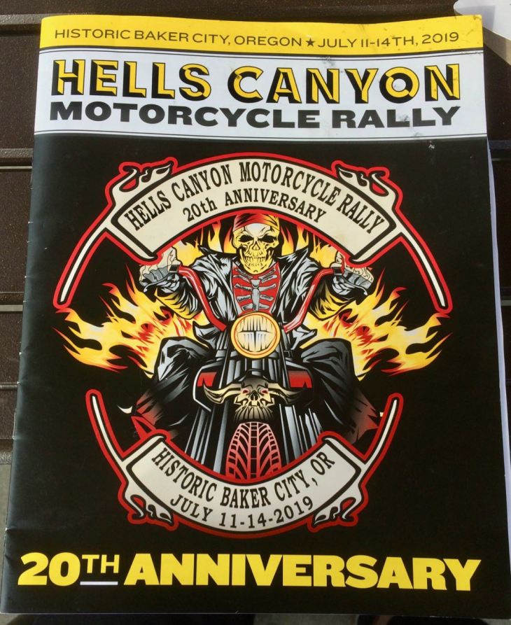
One couple was from California, another from Saskatchewan. I asked what they enjoy about rallys. They replied that it’s the only time they see each other.
Both couples had been to Sturgis, the largest motorcycle rally in the world. However, only one had been back to Sturgis, while the other muttered “once was enough for us.”
Day 2

Day’s distance / Total trip distance: 300 miles / 670 miles
Total travel time: 8 hours with stops
The weather today was quite nice. The morning started in the mid 60s, down to mid-50s in the mountains and up into mostly the 70s. Cloud cover varied from deep blue behind cumulus to mostly sunny.
Again, I shortened this trip from my original plan, cutting off about 2 hours of what was an ambitious day. This allowed me to be more relaxed, stopping when I wanted, etc. throughout the day.
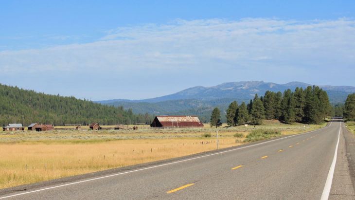
Not to worry, though. There were plenty of ideal (for me, anyway) motorcycle roads. Two-lane scenic highways, county roads with almost no traffic, near-perfect pavement, plenty of photo opportunities.
Highway 7 between Baker City to Austin, OR

The cafe in Austin was closed and the business for sale. Bummer 😦
County Road 20 (CR 20) was next. I rode this a few years ago and wanted to ride it again. It is about 40 miles of bliss, with minimal traffic and good pavement.
Galena is a tiny community of homes in the middle of CR 20 (aka The Middle Fork Road). I think these are local “landmarks” in the broad sense. 🙂
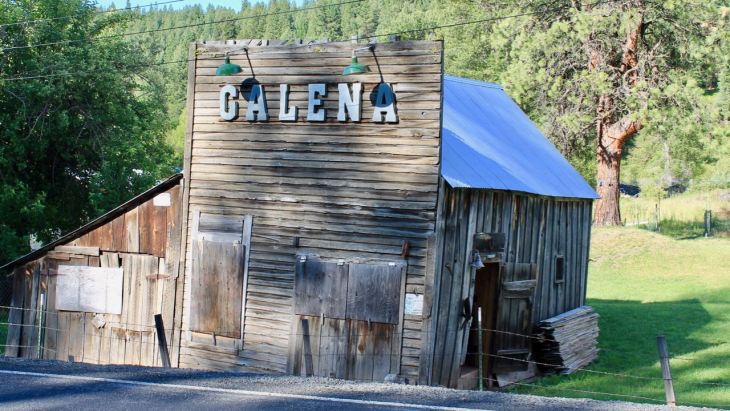

County Road 20 follows the Middle Fork of the John Day River and is close to perfection. Do watch for boulders that fall onto the roadway.

I stopped in the small town of Long Creek after turning south on Hwy 395. The OK Garage has ethanol-free premium and a small store, so I filled up the tank and had a cold coffee drink.
I did meet another biker who has also done a fair bit of distance riding named Chris while hanging out. He asked if I’ve ridden Dooley Mountain Highway. At first I didn’t recognize the name, but he pointed it out on the map (Oregon State Route 245) and I remembered it right away (as having gravel around many of the corners that spring).

Well, Chris had a job to do I had roads to ride, so I headed west through Monument, Spray, Fossil and Shaniko.
This notable section just north of Antelope on the way to Shaniko, OR …
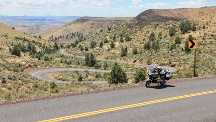
where I would stop for a water and to say hello to a few bikers. Did I just crop out the Ducati? I did. (hehehe)

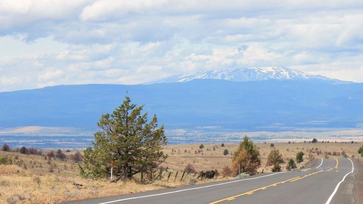
After Shaniko, it was Interstate 97 and, this photo from Highway 197 looking ahead to the town of The Dalles, my layover for the night.
While it would be hyperbole to say today’s ride seemed like a Spring day in Eastern Oregon, there was still a component of Spring in the green grass and seemingly hydrated forests for mid-July.
My room wasn’t ready when I arrived (I told them I’d be arriving later as I hadn’t shortened today’s route yet – no biggie for me as I was hungry.
It was Taco Thursday at the Tacos Tumbras truck less than a mile away and I still had my gear on, of course. Rated 4.7 and many folks were ordering in Spanish. A good sign.
Nicely grilled Al Pastor tacos for me! $1.75 each. Try the green sauce. 🙂

Tomorrow I’ll be riding through the Gifford Pinchot National Forest before going by Mt Rainier on my way back to Seattle. Stay tuned!
Day 3
Day’s distance / Total trip distance: 275 miles / 945 miles
Travel time: 8+ hours with stops
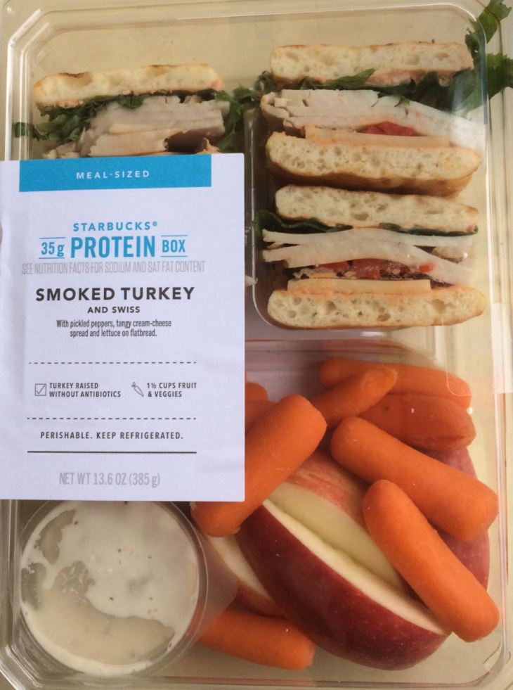
The day started a little later than I hoped. I pulled out of the motel about 7:30 and by the time I fueled up and grabbed a latte and lunch from the local Starbucks, it was after 8am.
I started by taking the Historic Columbia River Highway (Hwy 30) from The Dalles to Mosier before hopping onto Hwy 84 for the remaining few miles to Hood River.

Hwy 30 gets really twisty near the Rowena Crest Viewpoint. 🙂
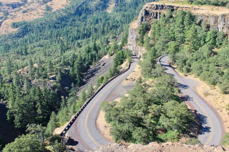
The difference between taking Hwy 84, seen adjacent to the river in the photo below, and Hwy 30, where the photo was taken, is quite clear from the viewpoint.

A final shot from Hwy 30 from just before Mosier looking towards Hood River where I would cross back into Washington State.
Once across, I headed west to Carson, WA where I would turn north onto the Wind River Hwy and into the Gifford Pinchot NF.

The Wind River Hwy (NF 30) was in great shape. Once out of Carson, it turns into Wind River Road and is hardly used except by occasional logging trucks (so keep an eye out).
Wind River Road took me to Meadow Creek Road, then Curly Creek Road where I was able to see Mt St Helens in the background.
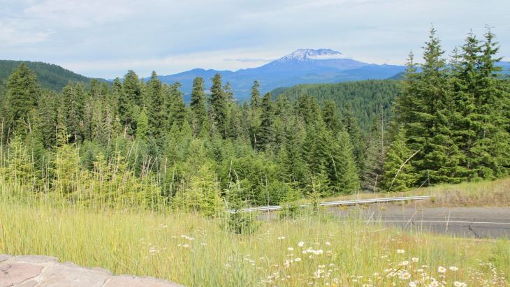
And an up-close view.
NF-90 was next, followed by NF-25, which would take me most of the way to Randle.
Although I wasn’t planning on riding to Windy Ridge, I did take a detour up NF-99 and headed in that direction.
NF-99 is about 16 miles long and takes visitors to the Windy Ridge Viewpoint. On this day, I made it to the Interpretive Site Monument Entry viewpoint.
Maps will tell you that it takes about 35 minutes to get to Windy Ridge. That is not the case given the condition of this road. It took 20+ minutes to get the first third of the way.
Of all the national forest roads traveled today, NF-25 and NF-99 were in the worst shape. Plan at least twice as much time as the map programs tell you it should take to travel them and take your time. Repairs are ongoing on NF-99 and there are frost heaves that will swallow small cars on NF-25. Just saying.

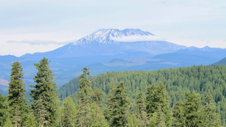
The eruption of Mt St Helens happened 39 years ago, in March of 1980.

Here is what it looked like today.

I took some time to think about natural disasters and eat my box lunch I brought with me. These are good when you expect to be eating lunch in the middle of nowhere. 🙂
I decided to turn around here and not continue to the Windy Ridge Viewpoint today. I’ll save that for another ride.
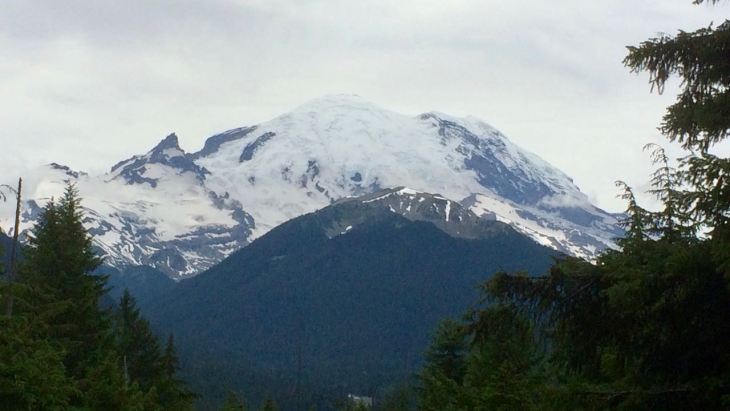
My next destination was the Mount Rainier National Park, which I would enter from the south using Hwy 123.
Hwy 123 is a well-maintained, sometimes twisty road I’ve ridden many times. Turning north on Hwy 410 took me past the eastern side of Mt Rainier. Too bad the clouds moved in. 😦
This shot is taken from just north of the turnoff to Sunrise Road.
At this point, there was no further avoiding tourists and traffic, so I hopped back on the bike and focused on getting home safely.
I arrived at 3:30pm, safe and sound. I’ll have some reflections on this trip written up in the next few days. In addition, I’ll create a permanent page for this trip under the Adventures tab.
Thanks, as always, for following along.
Reflections

Taking time to look back at the ride with a little perspective.
Highlight of the trip
The riding on Day 2 was the highlight of the trip. I chose familiar and worthy roads while nature provided near perfect weather and the scenic backdrop.
Excellent internet connections
Access to the internet at motels in 2019 is leaps and bounds better than five years ago. I had no issues connecting, uploading photos, editing the blog or streaming either night (Quality Inn, Baker City and Motel 6, The Dalles).
Metzler Roadtec 01 tires performing well
I have 2,100 miles on the new tires. They are performing well – exhibiting neutral, linear behavior turning into corners. sticking well to the pavement, providing a softer ride over imperfections.
And, the tires are wearing well. I see no early signs of scalloping on the front tread and the both tire’s profiles remain well shaped, a tribute to the different compounds used in the tire’s construction.
At this time, I expect these tires will be useful for a total of 8,000 miles or so. We’ll see in a few months if I am close.
Longer days in the saddle
For this trip, I had three days of 8+ hours in the saddle. The distances covered in that time ranged from 275 miles to 370 miles.
Covering 400+ miles in a day on the interstates is pretty easy on the motorcycle I ride. What I have to remember when planning a ride is the twister the road is, the longer it will take to rack up the day’s miles.
I shortened both the first and second days of this trip after more carefully estimating the time it would take to traverse my intended routes through the mountains using backcountry highways.
A rule-of-thumb for planning purposes moving forward might be:
- 300 or less miles of twisty, backcountry roads
- 400 or more miles of interstates (my record is 540 miles)
Getting enough sleep each night
I had some trouble sleeping this trip. It wasn’t that I wasn’t getting to sleep early enough. Instead, I would wake up too early and be unable to return to sleep. Each night, including the day I departed, I woke up on my own at 5am.
I have a few ideas for my next trip, including getting to sleep a bit earlier and starting to use an alarm to wake up – training myself to sleep until the alarm I set the night before goes off. We shall see how it goes!
Changing riding patterns?
By this time last year, I had two trips and 46 days of travel complete. This year, so far, I have logged only 12 days of travel. Two days to Seaside, Oregon and back, seven days in British Columbia riding to Desolation Sound and this past three days riding through Oregon.
Have my riding patterns changed?
Perhaps. But, it may be just a slow start to this particular riding season.
You see, the year felt wet and cool well into the traditional riding season here in the Northwest. Also, I had a late-spring BC trip planned since late last year. So, it seemed there was no pressure on me to hit the road earlier than that late-May adventure already scheduled.
Where to next?
I am planning a solo trans-Canada motorcycle adventure for September. This will be a ride from Seattle to Halifax, Nova Scotia. It will take roughly twelve days to arrive and I’ll set aside another two days in that area before heading home sometime during the last week of September.
The route home will be determined while on the road. The summer tourist season will have passed and I think I can get away with planning a day or two ahead. Besides, fall weather can be tough to predict and I’ll use weather forecasts to help plan.
Stay tuned for updates on this ride.
