
Temperatures ranged from 50 to 78 and the skies were mostly clear all day.
Day’s distance: 268 miles
Total trip distance: 617 miles
My original goal today was to get to the coast, but when I was programming my route into the Garmin (GPS) this morning, I realized that was going to make for a very long day if I used the back roads as planned. Since I was here to see the back roads, the only choice was to shorten my day. 🙂
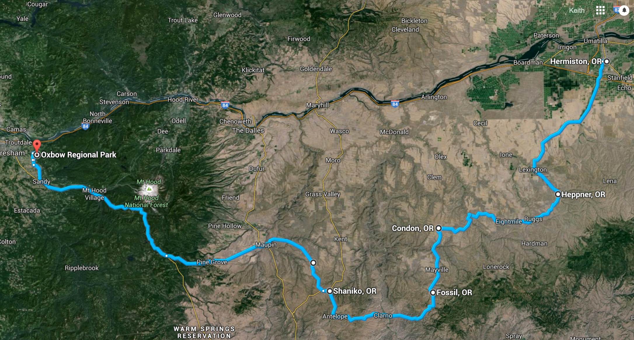
In order to convey the variety of landscapes I traveled through today, I’m adding a satellite view of my route.
After checking the weather around Mount Hood to see how cold it would get tonight, my new goal was to camp at Still Creek as I had done on my 2015 Trip to Wallowa Lake. With my route set, I was ready to head out. The time was about 9:15am.
I traveled Hwy 207 to Lexington and turned south on Hwy 74 to Heppner. The road took me past what seemed like very large farms stretching virtually as far as I could see. The two-lane paved road was in good shape, with a few gentle turns to accommodate the slightly hilly terrain. Traffic was light, locals mostly with a camper now and then.

On reaching Heppner, I found an storybook small town.


I took Hwy 206 to Condon. Along this part, the valley seemed to narrow and the otherwise gentle turns were punctuated by the more frequent and interesting turns. There was a good set of curves about 2/3rds of the way, including a downhill hairpin and a set that looked snake-like.


I stopped in Condon for an early lunch.

I chose a cafe & retail shop named Powell’s because they had an espresso sign. I had a chicken bacon wrap with a latte. Both were good, unexpectedly so 🙂
From Condon, I headed south along Hwy 19 to Fossil. The valley continued to narrow turning into more of a dry ravine at times and then open up again revealing smaller farms and ranches. The road was generally in good shape with some patches from prior maintenance work. Not as smooth as before but not too troubling.
Today’s tidbits: Fossil is a town intersected by the 45th parallel, according to a sign I read. This means it’s located halfway between the equator and the North Pole. It is known for fossil beds named after John Day, and explorer from the early 1800’s that are located near the town.

The variety of scenery seemed to just get better and better this day. West of Condon are the John Day Fossil Beds located at multiple sites. The local landscape at the Clarno Unit was other wordly.


Entering Antelope, I turned north to Shaniko and from there I headed to Maupin using the Bakeoven-Market road. This was a view of Mount Hood, my destination, from across a wide valley.

There was a series of switchbacks coming down into Maupin that would have been more fun if the gravel kicked off the shoulder by trucks in the tight turns. I just took it slowly and avoided sliding.
The Deshutes River runs through Maupin and it was here I took a break to have a soda.

I met two riders on Harleys from Iowa. They were heading to Astoria to then travel down the coast and return to Iowa along route 66.
Taking highway 216 west towards Government Camp, I began to discern what I thought was a wildfire near Mount Hood. I couldn’t find any information on it online and reached out to Will, who was at work, to see if he could find anything online while I continued onward. Neither of us found any information and it now seemed to the east of Mount Hood, so I stopped worrying about it.
After stopping for fuel, and taking a photo of Mount Hood …

I reached Still Creek Campground to find it closed. 😦
In fact, I found all the Mount Hood National Forest campgrounds in the area were already closed for the season. That seemed a shame on a day when it was 78 degrees and only dipping into the 50’s at night. Oh well, it was time to come up with a new plan.
I remember about a County Park that allowed camping near Sandy, Oregon called Oxbow Regional Park. I called and they were open and had plenty of spots. I let folks at home know about the change in plans and headed there to find it to be a wonderful campground, situated along the Sandy River.


It was quiet at night and I slept well.

Great route, done it several times..
LikeLike
First time on most of Day 2. I like discovering these places only to find they were only secret to me 🙂
LikeLike