
Day’s distance / Total trip distance: 275 miles / 945 miles
Travel time: 8+ hours with stops
The day started a little later than I hoped. I pulled out of the motel about 7:30 and by the time I fueled up and grabbed a latte and lunch from the local Starbucks, it was after 8am.
I started by taking the Historic Columbia River Highway (Hwy 30) from The Dalles to Mosier before hopping onto Hwy 84 for the remaining few miles to Hood River.

Hwy 30 gets really twisty near the Rowena Crest Viewpoint. 🙂
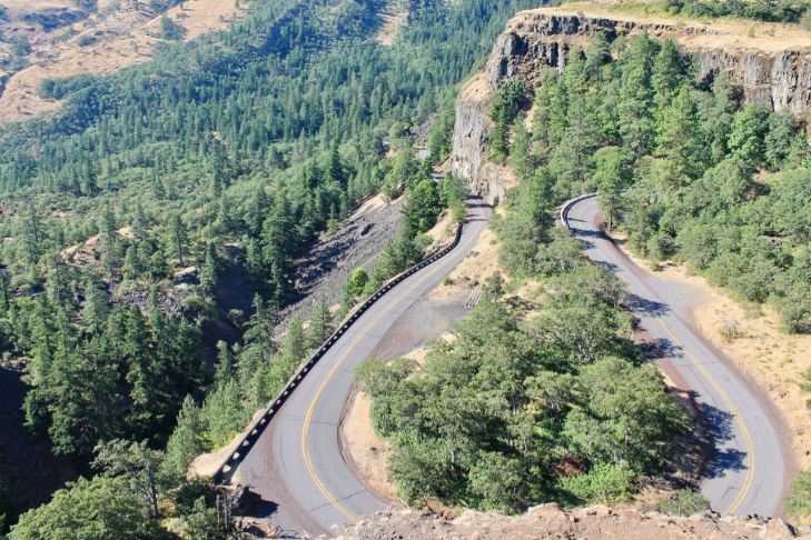
The difference between taking Hwy 84, seen adjacent to the river in the photo below, and Hwy 30, where the photo was taken, is quite clear from the viewpoint.

A final shot from Hwy 30 from just before Mosier looking towards Hood River where I would cross back into Washington State.

Once across, I headed west to Carson, WA where I would turn north onto the Wind River Hwy and into the Gifford Pinchot NF.

The Wind River Hwy (NF 30) was in great shape. Once out of Carson, it turns into Wind River Road and is hardly used except by occasional logging trucks (so keep an eye out).
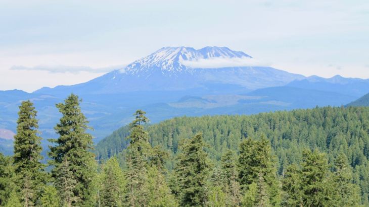
Wind River Road took me to Meadow Creek Road, then Curly Creek Road where I was able to see Mt St Helens in the background.

And an up-close view.
NF-90 was next, followed by NF-25, which would take me most of the way to Randle.
Although I wasn’t planning on riding to Windy Ridge, I did take a detour up NF-99 and headed in that direction.
NF-99 is about 16 miles long and takes visitors to the Windy Ridge Viewpoint. On this day, I made it to the Interpretive Site Monument Entry viewpoint.
Maps will tell you that it takes about 35 minutes to get to Windy Ridge. That is not the case given the condition of this road. It took 20+ minutes to get the first third of the way.
Of all the national forest roads traveled today, NF-25 and NF-99 were in the worst shape. Plan at least twice as much time as the map programs tell you it should take to travel them and take your time. Repairs are ongoing on NF-99 and there are frost heaves that will swallow small cars on NF-25. Just saying.

The eruption of Mt St Helens happened 39 years ago, in March of 1980.
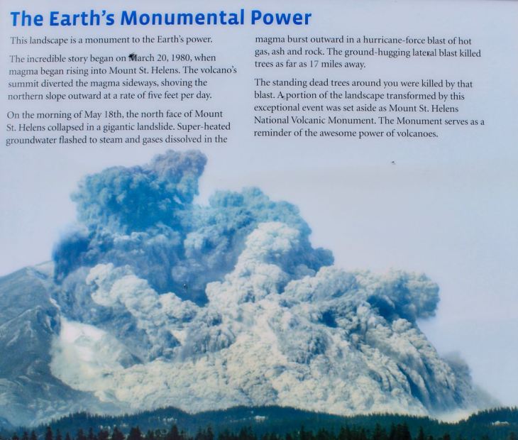
Here is what it looked like today.

I took some time to think about natural disasters and eat my box lunch I brought with me. These are good when you expect to be eating lunch in the middle of nowhere. 🙂

I decided to turn around here and not continue to the Windy Ridge Viewpoint today. I’ll save that for another ride.
My next destination was the Mount Rainier National Park, which I would enter from the south using Hwy 123.
Hwy 123 is a well-maintained, sometimes twisty road I’ve ridden many times. Turning north on Hwy 410 took me past the eastern side of Mt Rainier. Too bad the clouds moved in. 😦
This shot is taken from just north of the turnoff to Sunrise Road.

At this point, there was no further avoiding tourists and traffic, so I hopped back on the bike and focused on getting home safely.
I arrived at 3:30pm, safe and sound. I’ll have some reflections on this trip written up in the next few days. In addition, I’ll create a permanent page for this trip under the Adventures tab.
Thanks, as always, for following along.
